 |
The Airborne Antarctic Ozone Experiment (AAOE) was based in Punta Arenas, Chile during August and September 1987. This data was collected onboard the NASA ER-2 high altitude research aircraft as it flew south into the ozone hole. How are date, chlorine monoxide and ozone concentrations related? The famous graph is the one from September 16. |
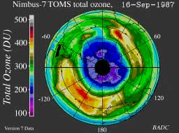 |
For comparison purposes the TOMS satellite data is linked here. The ER-2 aircraft flew south from Chile. The tip of South America can be seen at the upper left. The circles around the South Pole (latitude 90 degrees south) are spaced by 15 degrees so the data shown above starts (latitude 60 degrees south) at the second circle around the south pole. |
Airborne Antarctic Ozone Experiment
ER-2 Data | Ozone Hole | ChemConnections